This site is available in multiple languages: Deutsch, Русский, عربي.
In the Middles Ages, fields and meadows stretched from the Elbe to the Bürgerwiese what would later become the Großer Garten, as well as on toward the farmlands of Striesen and Blasewitz. In the beginning, they largely belonged to the Augustinian monastery in Altendresden (Dresden-Neustadt) and the Maternihospital, which had already opened its doors by 1287. After Duke Heinrich the Pious abolished monasteries in the year 1539, lands belonging to the Augustinian monastery became the property of the sovereign, and the fields along the Elbe were transferred to the Stables Authority. Between the Elbe and Tatzberg lay the Brückenwiese, which until 1852 belonged to the Bridge Authority.
Verdant Paradise and Destination for City-Dwellers
The outline of the modern-day Johannstadt more or less corresponds to that of the Ranvoltitzer Flur, the border of Ranvoltitz—a small village first officially mentioned in 1310. Its inhabitants lived off of fishing in the Elbe, farming and harvesting local deposits of loam. In the eastern region—from about Hertelstraße to Trinitatisfriedhof—was the border of the Blasewitzer Tännicht, a spruce and pine forest that was supposedly home to a rich stock of rabbits and partridges. On old offical documents, Blumenstraße—which runs through north Johannstadt today—was labeled as Jagdweg/Fürstenweg (Hunting/Prince’s Way).
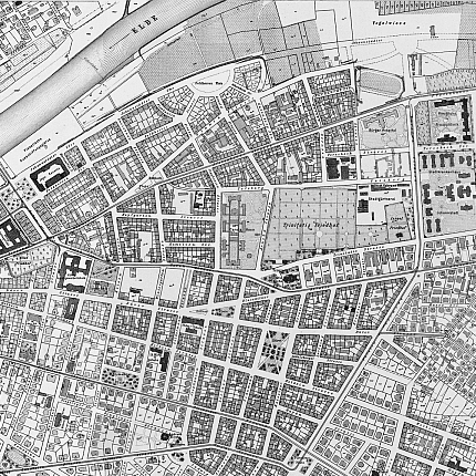
Around 1800, the pastural idylls of “Hopfgartens”, “Stückgießers”, “Engelharts” and “Antons” provided residents of Dresden with spots for recreation. On Sundays, Dresdners made their way through narrow alleys out into the area in front of the city fortifications. There were sumptuous flower gardens (Blumenstraße). In 1859, florist and trade horticulturist Lüdicke created a very popular winter garden (Wintergartenstraße), which remained a botanical tourist attraction until 1878, with its particularly rich assortment of camellias (Kamelienstraße, no longer in existence). The ferry company and the Elbe baths ushered residents on to their pleasant pasttimes.

Expansion of traffic routes and industrialization
After 1846, expansion of the so-called Environ-Weges toward Eliasfriedhof—at the time, halted—started up once more. Today’s Güntzstraße is one part of this former street which, thanks to trams, was later integrated into the “26th Ring”. The first ground-breaking ceremony for the construction of the horse-drawn railway took place at Güntzplatz on March 19, 1872. The railway began operation on September 26, 1872, initially travelling only between Blasewitz and Pirnaischer Platz. With the completion of the Albertbrücke on November 19, 1877, industrial growth kicked off in the suburbs east of Dresden.
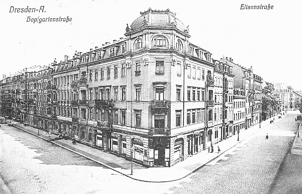
Thanks to the construction ban of 1874 being lifted—and the horse-drawn railway now operating—development and population growth continued at a steady clip. In 1876, Johannstadt was declared a purely residential district. With this declaration, the horticultural nurseries which had settled in the area were forced to make way for new residential construction. They moved further east, mostly into rural Striesen, where there was still free open space. In 1875, the long-planned and hotly-debated “high bank line” was finalized along what is now Käthe-Kollwitz-Ufer. Thus the threat of over-development on the Elbwiesen was thwarted indefinitely. In 1880, the construction of the ranger barrack began on Sachsenplatz. It was the most beautiful barrack in 19th-century Saxony.
The progress of industrialization’s took hold most noticeably in north Johannstadt. Commercial enterprises could be found in countless inner courtyards and buildings. Precision mechanics, camera and cigarette industries were predominant in the area. Factories producing machines, cardboard and curtains were also constructed, with locations on Blasewitzer Straße and Pfotenhauerstraße. The Heinrich Gläser company set up its home on Arnoldstraße and became famous throughout Germany for its auto-body manufacturing. On Bönischplatz, the traditional Munich brewery “Eberlbräu” established a branch for bottle-filling.

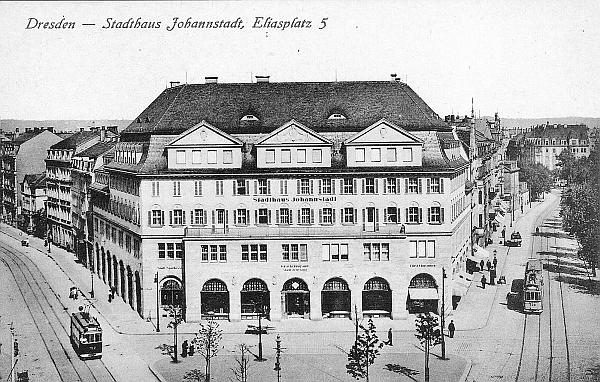
At the turn of the century, Johannstadt was one of the most populous neighborhoods in Dresden. From 1880—when only 940 people were counted—the number of inhabitants grew to 52,161 in 1900, reaching a population density of 149 inhabitants per hectare. Thanks to its increasing industrialization and the subsequent influx of labor, Johannstadt became the most populous neighborhood in Dresden in 1910, with 60,843 residents. In the years that followed, the population decreased once more due to people moving away and, most importantly, the First World War. In 1933, the number of residents was recorded at 56,853.
Destruction, Debris Removal and Reconstruction
The aerial attacks of February 1945 destroyed practically all of Johannstadt, save a few residential areas, particularly in north Johannstadt at Bönischplatz, Thomas-Müntzer-Platz and Hertelstraße. The neighborhood became the largest contiguous area of ruins in Dresden. Various sources testified to the destruction of 75 to 80 percent of the district, as well as the remaining four to five thousand residents. According to historian commissions, 2,000 Johannstadt residents lost their lives. The amount of rubble was later reported to be 19 cubic meters per resident.
Also nearly obliterated were the industries located predominantly in Johannstadt-Nord: the Laube machine factory, the Jasmatzi cigarette factory, the Römmler & Jonas art printing plant, the Saxon Cardboard and Maschine Consortium on Blasewitzer Straße, as well as the Gläser Body Factory were nearly 100% destroyed. Then there were the many small handicraft businesses and various shops that were bombed. The tram depot on Pfotenhauerstraße also suffered heavy damage, many tramcars either having been housed or out on the lines.
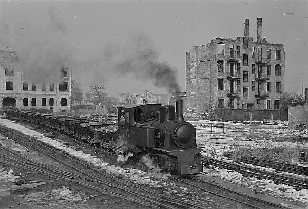
Like everywhere else in Dresden, the emergency clearance of the roads was of highest priority. As things developed, Johannstadt became a model region for various stages of reconstruction, first for the complex process of rubble clearance, then later for its blocks of new construction in the industrial Großblockbau style.
On January 13, 1946, work to clear the rubble began on Thomas-Müntzer-Platz. In coordination with the start of large-scale rubble clearance, two consecutive rubble rail lines were set up. The so-called T2 route entered service in the middle of 1946. From its start point at Nicolaistraße, it traveled onward to the dump on the former Vogelwiese grounds at Käthe-Kollwitz-Ufer. It was here—from Antons-Bad down Emser Allee to Käthe-Kollwitz-Ufer—that the masses of debris from Johannstadt and the Pirnaische Vorstadt were dumped. Facilities for sorting and preparing debris were set up at Dürerplatz and at Thomas-Müntzer-Platz, as well as on the plot of land on Gerokstraße where the Carolahaus once stood. The Gerokstraße preparation facility would later grow into the Plattenwerk Dresden, where production of large concrete elements began at the end of April 1955.
The first building plan was enacted on January 5, 1946. It envisioned the restoration of those apartment buildings which had only been lightly to moderately damaged, as well as the construction of new apartment buildings. Reconstruction started with Comeniusstraße, then in the 50s came apartments on Fetscher Straße and Striesener Straße which were built according to blueprints by architects Wolfgang Hänsch and Johannes Rascher. For the first time, traditional building methods were eschewed in favor of pre-made roofing and flooring elements, installed with the aid of rotary cranes.
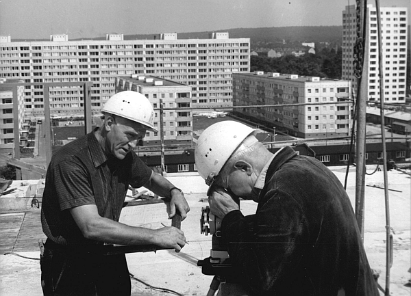
The planned reconstruction making use of concrete slabs began in 1968/69. During the first phase—under the leadership of architect Udo Fehrmann—2,523 units were built in Johannstadt-Süd by 1971. They were built in Großblockbau style as five- and ten-story apartment buildings. Expansive, green inner courtyards offered space for children to play and for residents to hang laundry and relax. In 1972, construction began in Johannstadt-Nord. Under the leadership of architect Kurt Röthig, 15-story towers, as well as ten- and eleven-story apartment buildings containing 3,800 units were built by 1975. Both residential complexes were outfitted with public buildings like schools, child facilities, shopping centers (such as the so-called Modrow-Kaufhalle—the largest of its kind in Dresden), polyclinics and youth clubs.
The GDR and Post-Reunification Revitalization
The character of north Johannstadt during East German times was exemplified by such things as the yearly Johannstädter Festspiele on the Elbe near the Johannstadt ferry, as well as several projects for Kunst am Bau (gable design for the world festival). A double Dresden-Atrium type schoolhouse was built on (today, the 101. Oberschule “Johannes Gutenberg”). At the time of reunification, residential buildings on Florian-Geyer-Straße already possessed a modern communal antenna system for satellite reception.
The area around Tatzberg began its transformation into a hot location for biotechnology and biomedicine with the revival of the biology department at the TU Dresden in 1994 and the pharmaceutical research at the Uniklinikum Johannstadt. Institutions later founded include the Max Planck Institute for Molecular Cell Biology (1998), the Medical Theoretical Center of the TU Dresden (2000) and the BioInnovationszentrum (2004). With the groundbreaking of the new building for the German Center for Neurodegenerative Diseases within the Helmholtz Association and the Center for Innovation Competence B CUBE (2016), Johannstadt took its next big step in becoming a “biopolis”.
Text: Matthias Erfurth
Find more information about the history of the neighborhood at www.johannstadtarchiv.de. For deeper analysis of the neighborhood history, come along along with us on a historic walking tour through North Johannstadt.
